Apple Maps turn-by-turn voice navigation goes live in Australia

After first being promised in October, then being delayed into November, Apple has finally rolled out iOS 6 Map’s turn-by-turn voice navigation functionality to its users in Australia. Responding to a customer email in September regarding the feature’s availability in Australia, former Apple Senior Vice President of iOS Scott Forstall said that the data needed to be exceptional and qualified before the on switch was flicked.

[Source: 9to5Mac]

Google bags patent for directions based on cell coverage

Want to get somewhere, but don't want to miss an email, or risk a break in the directions on the way? A patent granted to Google suggests it's been thinking about the very same thing. Read through the details, and it all sounds fairly familiar -- receiving origin and destination, planning a route etc. But, this time, there's the added hop of accessing wireless coverage data, and stirring that info into the returned directions mix. The flow charts in the literature suggest that this could be a user input option. So, along with the choice of fastest and most economical, maybe some day we'll be seeing one for "fastest data" too. Someone resurrect the term "information superhighway," and quick.

[Source: Engadget]

Updated Google Map Maker accents neighborhoods, shows changes in Activity Strea

Google wants you to think locally with its new Map Maker update featuring neighborhoods and an Activity Stream to track mapping changes. The site now launches into My Neighborhood mode, suggesting places you've rated or searched on Google Maps and allowing you to add and edit your own haunts. From there, a list of your changes (or those of other users) can be viewed in the left-hand pane and filtered by review, date or category. You can also see additions anywhere in your current map view by panning, zooming or searching and even help other users out by reviewing pending edits. If you're ready to channel your inner cartographer, check the source.

[Source: Engadget]

Google introduces Maps Tracks and Geolocation APIs, awaits your next location-enabled application

In its never-ending quest to dominate the global mapping scene, Google has just rolled out a new pair of APIs designed to help organizations build their own location-enabled applications. The first is Google Maps Tracks API, which gives developers the ability to concoct apps that can store, display and analyze GPS data on a map. In other words, those in need of a geofencing program -- fleet managers and the like -- need look no further. Secondly, there's the Google Maps Geolocation API, which "enables an application or device to determine its own location without the use of GPS by looking up the locations of nearby WiFi access points and cell towers." It's pretty clear that enterprises are the target here, but it seems like only a matter of time before consumer-facing location apps tap into 'em. After all, the world needs more indoor mall apps. Fact.

[Source: Engadget]

Google Maps or Apple Maps

Which one is better, Google Maps or Apple Maps? This is an important question for people looking to upgrade to a smartphone. Both the Android and iPhone offer GPS software, but each type offers its own strengths and weaknesses.

Let’s take a look at the pros and cons of each.

Apple Maps
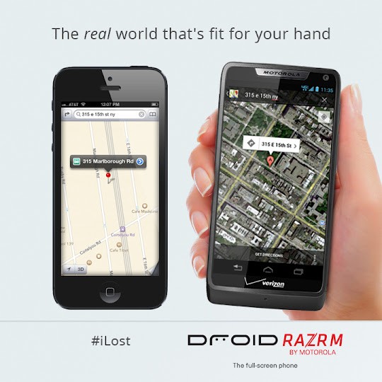
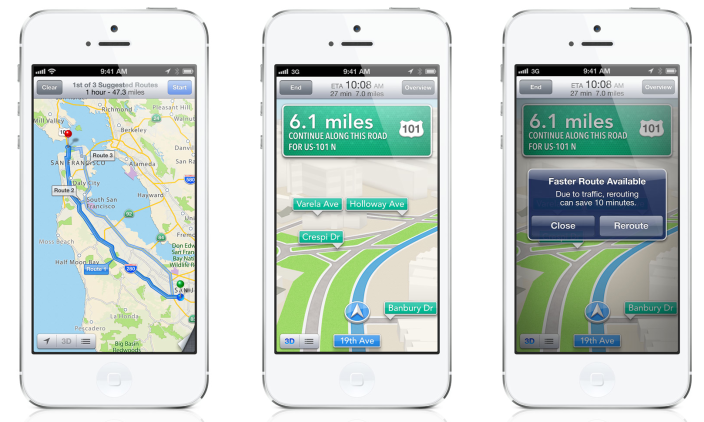
Apple has a history of winning over buyers with their products, creating a loyal pool of customers who camp on sidewalks and wait in hours-long queues for each new item that the company releases. Apple devices are nice, no question about that. However, Apple may have dropped the ball with Apple Maps.

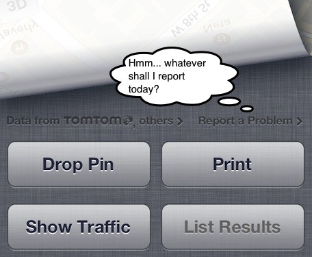
The newest version of Apple Maps that comes with the iPhone 5 has been identified by users as having numerous flaws with both the interface and the information it offers. The program has identified points of interest in the wrong locations, has labeled walkways and bike paths as driving routes, and has given outright false directions. It also only provides directions in text, but does not provide verbal directions, which is difficult for people who use Apple Maps while they are driving. Finally, it provides no information about public transport.

The problems were so widespread that Apple CEO issued a public apology and promised to fix the bugs, but also suggested that users download apps from competitors, including HopStop, Map Quest, and Google Maps.
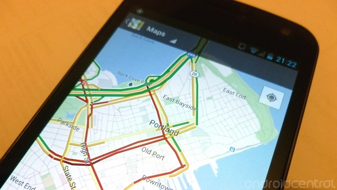
Google Maps
Since the CEO of Apple is recommending Google Maps, what’s so great about it?

Basically, it excels wherever Apple falls short. Google Maps provides audio directions and gives the correct labels for landmarks and street addresses. It also allows users to get the most current information about public transport as well as the best routes for bikes.

Locations stored within the program tend to be more accurate because Google allows feedback from users and then makes the appropriate adjustments, thereby securing the most current data. Google Maps has been around longer than Apple Maps and therefore has had more time to work out the kinks. Many of the features in Google Maps were available before the release of the iPhone 5, such as routing for urban public transport, which has been available since 2011.

Therefore it is clear that the technology has been available for a long time from Google, but Apple has failed to keep up. Though the new iPhone might look snazzy, you can get a better quality product from Android with a smaller price tag.

Apple has declared itself committed to fixing its navigation app, but until then, you’d be better off to sell iphone and get an Android with Google Maps, or if you have decided to keep your iPhone, download Google Maps from the App Store.

[sponsored article]

Apple's 3D Maps and Imagery See Incremental Improvements

Following last week's open letter from Tim Cook in which he promised that Apple "will keep working non-stop" until the iOS 6 Maps app meets customers' standards for quality, Apple has indeed been making improvements to the service. While there is certainly a ways to go, it is clear that the company is indeed moving quickly to address issues and improve coverage for the flagship 3D mapping and imagery features in the app. 

While improvements have been ongoing, MacRumors forum members yesterday began noticing what appears to be a larger set of additions to the 3D content in the Maps app, including both the satellite/aerial imagery and the standard maps. One region that was among the first to be noticed was the New York City area, with a number of improvements including new 3D imagery of the Statue of Liberty being seen.

We've also heard from users who have experienced new Flyover imagery showing up in Honolulu, Hawaii and in the San Fernando Valley in the Los Angeles area. The changes are also affecting the standard vector-based maps as well, with users reporting new 3D buildings showing up in New York City and London. 

Interestingly, not all users are seeing the new imagery, with some even doing side-by-side comparisons between devices with different results. The difference is presumably due to aggressive caching of maps and imagery, and users who are not yet seeing the new imagery should see updates in the relatively near future.

[Source: MacRumors]

Apple retail employees encouraged to report Maps issues

With many thousands of staffers in the US alone, Apple's retail team has numbers on its side. It also has geographic diversity, with stores in 45 of the 50 states. Lots of people in lots of places who presumably carry lots of iOS devices -- just what you need if, perchance, you're looking to clean up some facepalm-worthy glitches in a shiny new mapping dataset.

Gary Allen of ifoAppleStore tweeted early this morning that store managers are asking employees to report Maps errors that they see in iOS 6 while they are out and about while working, on the clock. We've independently confirmed that a communication to that effect did go out to retail staff members (at least in the US and Canada), although we don't know precisely what it said.

MacRumors suggests that the map quest will be fairly formal and well-organized, with teams of employees dedicating up to 40 hours per week, cumulatively, to the wayfinding fixes; submitted data would go through a dedicated Apple portal rather than being bundled with general user feedback. Allen's initial report suggested the effort would be voluntary.

Of course, calling for fixes to map errors isn't purely the province of those who are being paid out of Cupertino's hoard of dragon gold: you too can help the cause by reporting errors and missing features in iOS 6's Maps app. Tapping the page curl on the lower right corner of the map reveals several controls including the "Report a Problem" button, which in turn gives you all the necessary feedback options.

[Source: TUAW]

Tim Cook's apology shows that Apple cares, but still needs to fix problem

Last week I wrote an article criticizing Apple's new Maps capability explaining why it was a deal-breaker for me and why I was leaving the iPhone. That article generated hundreds of comments (in agreement and disagreement), tweets, and emails to me and TUAW, some going so far as calling for me to be fired. Since that article was published, the criticisms of Maps have exploded, so much so that Tim Cook released a rare public apology from Apple and pointed users to mapping apps from competitors. While that may help stem the bleeding until Apple can figure out how to fix its Maps mess, there are two things about Tim Cook's statement I want to address.

The first is that Cook's apology shows that Apple truly cares about its users. You know those times you mess up and realize how hard it is to apologize for your mistake? It's usually pride or embarrassment that gets in the way of apologizing. Either way, it's still incredibly hard to admit you were wrong. Now multiply that feeling by a million, knowing that your apology -- the admission that you were wrong -- will be reported by every major newspaper and tech blog in the world.

[Source: TUAW - Read the full story there]

Motorola pokes fun at iOS 6 Maps, wants to prevent people becoming #iLost

By now, the vast majority of Android users -- no, make that people in the world -- have heard about Apple's new replacement for Google Maps in iOS 6. Proudly announced during their iOS 6 keynote, replacing Google Maps was another step away from using Google services for the Cupertino giant. Since the launch, much has been said about the maps, and their apparent lack of some key information within the maps themselves. 

We'll admit it. It makes us chuckle. As we sit here using our native Google Maps, more and more we see comments arising from iPhone owners, both new and old, slating iOS6 Maps. And now, Google owned Motorola is joining in on the fun. 

Looking for 315 E 15th in Manhattan? Google Maps on DROID RAZR M will get you there & not #iLost in Brooklyn.

Seen on the Motorola Mobility Google+ page, and on their Twitter page, the message is clear. While an obvious advertisement for their latest handset -- and perhaps the RAZR M's edge to edge screen, compared to the 'stretched' iPhone 5 -- rather than Google Maps itself, we wonder how long before the #iLost tag will catch on. Probably until Google releases a third-party Google Maps application into the iOS App Store, but until then, we can but chuckle away.

[Source: Andoird Central]

Missing all the features of Google Maps? Get them back in iOS 6 with these third-party apps

Are you already feeling the frustration of Apple’s new iOS 6 Maps app? Apple is officially no longer using the Google Maps backend from iOS 5 with today’s public release of iOS 6. With its new in-house Maps app, some were concerned users would be disappointed with the arguably downgraded experience. A few of the reasons some users are refusing to update to iOS 6: lack of Google’s Street View and public transportation features, limited traffic data, and inferior local search. Above is a breakdown of lost features by country, courtesy of theunderstatement.com, showing 51 countries will be losing access to Transit data, 24 countries losing traffic data, and 41 countries without access to Street View. Also worth noting is that 20 countries won’t have access to Apple’s shiny new turn-by-turn and 3D Flyover features. Another consideration is that many of the features of Apple’s new Maps app, such as Flyover, turn-by-turn, and Siri, will be limited to iPhone 4S/iPhone5, and third gen iPad users.

[Source: 9to5Mac - Read the full article there]

Instagram 3's new Photo Maps feature adds location to your photo stories


Instagram 3.0, the free photo sharing app for iPhone, is available and provides a number of enhancements. The most impressive is the new Photo Maps feature.

By grabbing geolocation information that is saved with each photo, Instagram creates a world map of your images by location. As you zoom in on each location, say Florida for example, you see locations in that state, then in each city.

You can add new photos to your Photo Maps through the new photo upload screen, which features a prominent Add to your Photo Maps button. Instagram has also increased the length of the captions you can add to each photo, and provides a way to name a location.

[Source: TUAW]

Google adds real time traffic data in maps to 130 new U.S. cities, expands global coverage, too

Real time traffic information is a real day saver, and todays news from Google brings the service to a further 130 U.S. cities within Google Maps. 

These smaller cities such as Kalamazoo, Michigan and Portland, Maine, will now benefit from traffic information and estimated travel times around the arterial routes within the cities. Hit the source link below for more information on which cities have been added.

The United States isn't the only place to see expanded coverage either. Panama City, San Jose (Costa Rica) and Bogota all join in for the first time too. Additionally, the coverage is being expanded throughout parts of Brazil, Canada, China, Czech Republic, France, Germany, Italy, Mexico, Russia, Spain, Sweden, and the United Kingdom. Good work, Google.

[Source: Android Central]